Friday, March 26, 2010

Batu Gajah & Lawrence of Arabia

Prologue

Batu Gajah is another town that is close to my heart as we grew up here prior to bapak's posting to Lenggong.

However, since we were much younger then compared to when we were in Lenggong, we don't exactly remember the town itself, but thanks to three full set of album of pictures taken by bapak in Batu Gajah, we remember the house and the surrounding as if it were only yesterday.

But I have always wondered about Batu Gajah and where it got its name. Batu Gajah is supposed to be named after two large boulders that resemble elephant, at least that's what Wiki told me, but I have never seen them.

Of course as I have mentioned in previous entries, there is this limestone hill in Lenggong that was originally a giant elephant. We believe the elephant was cursed by Sang Kelembai and turned into a hill in the shape of an elephant.

But here is the story and the journey to find batu gajah.

Lawrence of Arabia di Batu Gajah

This is still Al Ula as per previous entry, but this time around, the journey would take us about 30 km out of town.
Along the way, we saw the green surrounding the Al Ula valley, and as we moved out of town, we started seeing rock formation and reddish tone.
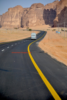
The road is good, in fact it is excellent and practically devoid of traffic - we are talking about being in the middle of the desert here obviously. Or shall I say that the road was 'deserted' (and that the pun was intentional?) ;-)

We saw all kind of rock formation - in different shapes and sizes, often left to our own imagination.

LIke this hill. What kind of animal do you think this is? Did Sang Kelembai use to live in Arabia too?
Then suddenly Bus No 1 swerved to the left and went off road and we were left breathless with the sudden turn. Would we, in the end, need to push the bus out of sand dunes?

Now, this could be one adventure I did not expect when I decided to make this journey.

But soon we were greeted with this sight, one of the many attractions of All Ula.
Obviously you can decide of what you want to name this rock formation.

Just in case you were wondering about my prologue to the entry. ;-)
Akmal posing in front of the Elephant Rock. It is now confirmed that Sang Kelembai actually lived in Arabia and later on migrated to Malaysia and made Lenggong its adopted hometown. ;-)

But I still wonder, what does it have against elephant? Do you know why?
Akmal, his mum and grandma and of course about 150 of us, all posing in front of the rock formation.

Looks like a giant elephant feet to me.

I was made to understand that this rock formation was not shaped by the wind but by the waves of the ocean as this area was flooded in the old days. Before the ice age? May be, I don't really know.

Then again it could have been shaped by sandstorms over thousand of years.

Any geologist here who could explain?

I think I failed my Physical Geo during high school ;-)

But what I am blabbering about here? It is the work of Sang Kelembai. End of story.

Tulis nama atas batu. Err, bro, ni bukan Jabal Rahmah or Kuala Kubu.
The whole contingent in 3 buses, admiring the hills in the desert
Close up view of one of the the hills. It looks like someone has decided to sculpture the rock.

Another view of the Elephant Rock and its surrounding.

When we are close to being done with admiring the rocks there, out of nowhere, this horseman appeared from the other side of the hills.
Galloping towards us as we head back to the bus. I don't think this couple realize what's behind them.

We were wondering about this guy - who is he and what is he doing here amidst the rocks, because we did not see him when we went behind earlier.
Dancing with the horse
We were quite impressed with the free show. Not sure if the organizer has anything to do with it. We doubt it to be honest.
Aaaah, no wonder he looks familiar; I think he is Lawrence of Arabia! ;-) (or may be this is how Khalid Ibn Walid looks like on his horse.) Acknowledging the rapt attention that he gets from all of us there with a smile.

Rugged man.

Seriously, I think he was just enjoying himself, showing off his prancing horse skill infront of 150 foreign tourists.

I only saw one person tipping him. The rest of us were just enjoying the free show. We weren't sure if he was doing it for the tips or by coincidence.


He starts doing his own stuff as we start leaving.


Hey, where's my tip?

It seems as if he was chasing Bus No 1. It adds drama to the tour anyway.

Anyway, here is something you may want to take the tour yourself.

Sunday, March 21, 2010

The Original Old Town


PROLOGUE

I had the title and even the content in mind when I was away for the two weeks in February. I was sure I was going to write it the way I saw it - nothing more, nothing less.

But I had second thought of writing my mind upon my return. I was told by Ustaz Andi, that it is better to write about the good things so as to encourage others to make the journey of a lifetime rather than discourage them.

Furthermore I thought what I had done, seen or experienced was way too personal for me to blog here in detail.

Sure, this is a personal blog. Everything that has been written is mainly for my internal consumption and record of my thoughts and my own journey in this world, but it is open to the world to read though 'open to the world' is a bit of an overstatement.

I realize that.

There are things better left unsaid or unwritten, I guess. So, many - it is relative anyway, will remain etched in my memory, untold.

There are many books or essay or blog - good and bad, written about this topic. I would welcome you to read them. Mine will always remain with me.

Unless I am invited over for some teh tarik sessions with some friends, like in the aftermath of the funeral of Atuk's wife on the 1st of March. ;-)

And may be over time I will be persuaded to change my mind.

Oh and please listen to Ron Goodwin while you continue reading this.

Al Ula Old Town

I guess it has nothing to do with white coffee and roti bakar kaya, so don't start looking for them. We were given a (small) cup of coffee upon our arrival as an Arabic greeting, but to be honest, I could not finish it off. The coffee and whatever in it was just too strong and the taste too peculiar for me.

But at least I can vouch for its halalness, compared to the local Old Town, right?

This is the real (and original) old town. Whatever else that we may have over in our malls are fake! ;-)

This old town is a unique example of an Islamic city from the classical period. its houses were built during the 13th century AD (7th centure AH) with extensive use of stone retrieved from the ruins of al-Khuraibah. Many of these stones bore inscription and decoration. These houses had no opening on the ground floor other than a fortified entrance. The ceilings were made of palm trunks and then covered with palm fronds and mud.


I am glad the Saudi government has decided against tearing this town down as they have always done with many other historic sites especially those related to Islam.

Bid'ah would be their reason to keep everybody quiet.

And this is one of the reasons I should be keeping my thought to myself.

As it is indicated, a castle, from which many of the pics below were taken could be linked to a Islamic commander Musa bin Naseer.

If you read carefully the inscription above, you would be amazed with the planning taken in building this town.

Al Ula, to the uninitiated like me before the journey, was an important mercantile centre located in the principal trade route in the ancient time linking southern Arabia like Yemen with the likes of Egypt and Syria. It lies 370 km North of Madinah al-Munawarrah.

It is related to the Kingdom of Dadan dated fifth or sixth century BC.

Our prophet Muhammad, SAW, passed by Al Ula on his way to Tabuk in the year 9H (630 AD).

The Al Ula valley is blessed with fertile soil so it is a very important valley in producing fruits, grains and vegetable in Arabia.

We had the opportunity to visit this old town in February. Let's give you an aerial view of the old town first. This can be done by climbing up the castle next door to the town.

Halfway climbing the castle, one can now see the old village.
The old village is in the foreground, with part of the castle on the left. This old town has been left aside for conservation. The new town of Al Ula, where the current residents reside, is in the background.
A close up of the heritage village. It may look ugly and unkempt, but to my eyes, this town is so beautiful.

And now that we have an idea of how the village looks like, let's go inside.

We started going inside the village. It was quite late - very late actually, in the afternoon actually, but wanting to now more how people lived in the old days, we cast aside any doubt or apprehension.
Charles Doughty who visited Al Ula in 1876, gave the following account of his visit, "The narrow town streets are very clean but very much darkened because of overbuilding, necessitates by the restricted ground area. At every door step, there is a typical Arabian style clay bench."

"There is no litter in the streets and dogs are not allowed to walk by. There is no market either and daily provisions are sold after sunrise at street corners; mutton and goat meat are sold in mid afternoon outside the city walls and every inhabitant comes out to sell the fruits grown in his own house garden."
A street in the old town. Narrow street is the feature of the town. The shape of the facade was probably inspired by incense burners or altars brought from al-Khuraiba.

C Doughty carries on with his account of Al Ula: "I sat down on a bench with a group of people, in the street; they were very friendly with me and none of them made any improper comment to me. Sheikh Dharir's son then came to invite me to have breakfast at his father's house before we went to the quest room. Every Sheikh has such a room in the ground floor of his house, where coffee is served at special times of the day."
Akmal posing along the lane we were not allowed to venture into, for safety reasons.

Inside one of the house.
More of the lanes inside the village. It surely feels like a maze of corridors inside the old town.
If you decide to be the last person, the atmosphere can be quite intimidating and the surrounding eerie.

At a glance, it does look like a cowboy's town. A deserted one that is.

This is the view at the back of the village. There is a sundial used to show the beginning of each season. May be here was the market in the old days.

Can you imagine people living here in the old days?

As pointed out, there is a castle on the side of the village on top of a hill/rock. To me it looks like a tower watching over the village.
This is the castle I mentioned above.


Part of the original staircase carved out from the hill 2600 years ago.


The view on the opposite side of the village.

The very first pix is the view of the hotel we were staying in from the castle.

Tuesday, March 16, 2010

Cycling Down Memory Lane

Kembara Blogger Hariri @ Lenggong on Saturday 13 March 2010.
I had never thought that at this age and time I would be doing this.

It is a nostalgic expedition - going through places that used to be our playgrounds, this time on bicycle and that house in the background and its compound were the ultimate playgrounds for the Hariris.
Our starting point was at our old house at Pokok Jerai near Simpang Labit.

Except for yours truly, the others are reasonably fit. They have been cycling for months already. I, on the other hand, have not touched the bicycle for more than a year now and that bicycle had sat in my house with two flat tyres until 3 days before the expedition.

To make matter worse, I have also not jogged for more than a month now.

To be honest, I am not much of a cyclist. Yes, I did my tour of Ipoh circa 1983/84 and when they were young, cycling was something I would do in the afternoon with the kids, but any day I would prefer jogging (on a treadmill) as I would not have to leave my home and not worry having to get someone to rescue me should I tire myself out.

So when I was asked to join, I said yes, but deep within me I was not too keen. The only reason I said yes was because of the location.

To me, it would be like cycling down memory lane and it was not something I would want to miss out.

We left Pokok Jerai at 8 am and reached Labit by 8.30 am, passing through Bukit Raja, which I had mentioned in my fotopages (it has an 'rumah tinggal' or 'rumah berhantu' right in the middle of the jungle in the hill), the beautiful paddy fields of Kg Teluk Batu (which I used to cycled across going to the other side of Lenggong main road) and off to Labit.

It took us less than 30 mins of leisure cycling to reach the river bank of Sg Perak at Labit.
And then I saw this beautiful scene. To me, it was as close as one can get to a picture-postcard scenery. I was so overtaken by the scene to be honest and thought that it was so tranquil and peaceful that I can sit here for hours and enjoy this scene. I am so glad to have lived in some of the most beautiful places in Malaysia.

Mind you the pic was unedited, so you can imagine the real thing from the picture above.

Sometimes I do wonder why do I bother going through these places as they bring back memories - sweet memories, of the good old days as it makes me yearn for the years gone by. Now if only someone had unlock the secrets of time travel...

And no, this was not the location we had our swim like in the previous posting. I am sure we had a more strategic location for our swim then, somewhere between Labit and Temelong.

Arif, Akmal and I were last here in 1999 when we dropped by on our way home from KB. At that time, there was still a boat service connecting Labit and Chepor. Now with two bridges on either side, there was no need for such service anymore.


From Labit, we had to cross the river using a boat. Of course it took 3 trips to transport us all including 3 bikes across the river. It was an uneventful crossing, just the way I like them.

As they are no longer serviced by boat, it was lucky for us that Latif knew who to contact for the boat ride.

YOu can see Chepor on the other side of the river in the above picture.

We were told that during those days, the Cheporians would have to cross over using boat if they want to have their teh tarik and the only location they could have teh tarik was in Lenggong town.

Nowadays, you would find so many gerais and warungs throughout the kampungs and they have no need to battle their way for their favourite drink.
The view right from the midpoint of the Perak River. The mighty river was tamed by Lokman and I in 1972.
As we approach Chepor...

From here on onwards, we had to find our way through the villages along the Perak River. We had though that we would be cycling through lanes along the River but it was not that straight forward. We had to find our way to Chepor, Pulau Cheri, Luat and Kampung Beng.
A kilometer inside the off road, we stopped to catch our breath due to the steep hill and to pressurize the tyre a bit more for the tandem bike.

However, one thing led to another, and we ended up having to replace two tubes for the tandem. Well, I didn't do anything at all. Just let the pro do the job here and luckily for me, well, my bike behaved like an old pro itself.

A cheap bike I must admit, but one that did not give me any trouble during the expedition, except that the owner is an old man who has difficulty moving his muscles (for long period) to power the bike.

That's the only problem, but that's not the bike's problem though. ;-)

After 4 km riding off road, we found our way to Pulau Cheri with its tarred road. It was a bit of a relief as eventhough this blogger had bought a spare tube, he left it inside the car he left behind at Pokok Jerai. So the spare tube would be useless in the event it was needed.

Some much for planning or in my case, non planning actually.

And then we went to Surau Pulau Cheri.
The compound of the Surau Pulai Cheri is immaculate. It also offers a very good view of Bukit Bunuh and the Sg Perak. The surau however was a non-descript wooden building.

But it was a very clean one.

The road leading to the Surau with a view. The hill on the right is Bukit Bunuh.

How did the hill get its name? Legend has it that there used to live a poor couple. One day the husband dreamt that in order to be rich, he would have to kill his wife. He related it to his wife and his wife agreed to be killed so that his husband would be rich and respected by the kampung folks.

Would you believe that? It is unthinkable nowadays, right? Then again, may be not. People do worst things than this, including murdering one's wife or children.

Herein lies disagreement on the finality of the story.

One school of thought said that while the wife was bathing in sintuk limau before being killed, there was this huge tempayan floating in the rives that contained riches that would last several general generation and they lived happily ever after.

Another school of thought said that after his wife was killed, he did not find any hidden treasure anywhere and were a broken man even worst than his fate before.

OK, it was just a legend recorded in the Archaeological Museum of Lenggong!
Pulau Cheri is central to our memory because of this house. Bapak used to 'mengaji' and 'berguru' with Lebai Johan on the weekends, and he would take me and my bro along and spent the night at this house.

There are many amazing stories about Lebai Johan and I guess Lokman can probably tell many of it. You can also read a bit on my entry on the 1969 riot to know about the background.

However during those days, the journey from Kota Tampan from the other side of the river can be quite tiring and taxing to kids like us. I think the walking distance could be more than 3-4 km, I am not sure. It seems short enough for us on bikes in 2010. It is this journey that we were trying to replicate with this expedition albeit being in reverse direction.

More stories can be found at latif's blog here.

However, I do wonder about Pulau Cheri. Isn't it a misnomer and how did it get its name in the first place? I had never questioned that name to be honest when I was a kid, and the area seems too big to be an island, and it certainly is not an island.

We then visited Pak Cik Hassan but I guess you can read more of that in Latif's blog.

Then we hit the Kota Tampan bridge which was not there during the 70s and we had to call for our sampan to take us across the river.
This is view from the Kota Tampan bridge in the direction of Kuala Kangsar. Right at the end of the river in the pic (on the right), we would have to call for the sampan to take us to the other side and then we would begin the 4-5 km walk. May be less, but the walk during those days is more difficult than currently as it was only a lane fit for a bicycle.

But may be then it was shadier than today.
Latif, Izzuddin and Rasi on the bridge. By this time, it is already noon and the sun is shining hard upon us that day.
Still the view from the Bridge (anyone remember Kim Wilde's song View from A Bridge? It is such a nice song.) This time towards the direction of Lenggong.
As were were cycling toward our (sampan) landing place in the 70s, we saw this nice (small) lake, and with Latif's tandem bike giving him problem that would require them to go to a mechanic, I took the opportunity to sit and enjoy this precious lull moment in my life.

Absorbing all that are before me.

Aah, relaxing under the shade and cooled by this small lake.

However, that was the end of the shady road for us. No more kampung road after this. Back to the main road and with the gradient and sun conspiring against us, we had to walk our way up this hill, with yours truly always the last person.
This was Latif and Izzudin walking their bike up the hill with yours truly way behind them. Rasi was nowhere to be seen as he was too fast for us.

No trees this time around to protect us against the harsh mid-day sun.


At times, along the way, one would think that it was snowing in Lenggong. One would find quite a bit of Pokok Kekabu along the way and I guess the whites of 'kekabu' on the roads and road shoulder as if it had been snowing. Of course the weather would not have allowed such freak of nature to occur.

I was wishing for it though.

We did go to Lubuk Kawah where we thought the rumah rakit that we used to frequent was. But by then, I was too tired and decided against going anywhere that would take me further away from Lenggong town.

After resting, we headed back to Lenggong.
As we cycled from Kota Tampan heading to Lenggong, we passed by Masjid Kampung Banggol Belimbing. It was quite a mosque and a landmark for us during those day. I thought it is a nice small mosque, well kept and maintained. The fact that Cikgu Ainon lives nearby would make it even more significant to us. When we saw the mosque on our way back from Taiping or Kuala Kangsar, one would immediately know that Lenggong is only a short-distance away.
From Banggol Belimbing, and Cha'in, I knew Lenggong is within touching distance. But we still have to conquer the inclined road leading to the town as shown in the pix taken by Latif/Izzuddin of yours truly pedaling hard.

It was nearly 2 pm, and at that point I was only thinking of the finishing line. "Just a little bit more," I was saying to myself, "once you reach the top, it would be downhill from there and you are home free."

All I can do then was lower my gaze, concentrate on telling my muscles to move my legs in a circular movement to pedal the bicycle forward.

Despite the aches.
Yes, once we reached the top, what a view it was, and it was all downhill from here. No need to cycle and just let gravity pulls you through pekan Lenggong and of course to Din's restaurant.

To me, it was a big relief especially since we didn't stop since Cha'in and the inclination of the road across SMDA, while it was nothing on a normal day, especially if one were driving, it was quite taxing for us as we were on our last leg of the expedition.
At last, meals and chat time at Din's Restaurant - Din was a classmate from my primary schooldays in Lenggong. We were able to sit and enjoy this moment, as we are practically done with the Kembara even if we are not at the starting point. And the remnant of the dishes were good actually.

All in all, we covered about 30 km that day and for practical purpose we completed the expedition by 2 pm, so it took us 6 hours or so to do so. It was not meant as a race against time. It was purposely a leisure cycle; we took the time to smell the roses, so to speak.

And the roses are sweet, I must say.

We managed to roll back the years in six hours.

EPILOGUE

Obviously I am not going to cover all angles. So you can read more at Latiff's I Spread My Wing blog. The entry is here.

More pictures can be found at my fotopages.
This is the map of Bukit Bunuh (right in the middle of the map). We were traversing along the Perak river on Eastern bank. It give some perspective of the location we were at during the expedition.